- Start off slow. It's easy to get injured if you start pushing yourself too hard, too early. Getting into a daily running routine after taking some time off, and getting into a daily running routine for the first time altogether are two different things. If you have never run before, you may want to limit yourself to a mile or two a day about 3 times a week. Take your time for the first month or two, and only increase mileage as you are comfortable. About a 10% increase in total mileage per 3 weeks is a good estimate.
- You need to stay hydrated and eat something before you run. Some of the hardest runs I have ever done were not the longest or fastest ones, they were the ones where I wasn't hydrated, or hadn't eaten anything in over 12 hours. You can look online to figure out how much water people recommend, but I just try and keep my urine on the clear side and not the Gatorade looking side. It took me a long time to realize that doing a long run without eating something a few hours before makes the second half significantly harder. Experiment with different foods to see which ones sit well and which ones give cramps and other problems. I personally like PBJ sandwiches.
- There are different theories on stretching before you run, but I think everyone would agree that stretching after and between runs helps a lot. For example, if your calves are tight, you may get shin splints. Stretching your calves for a few minutes during your day can help keep you healthy.
- Buy decent running shoes. You can go to somewhere like Runtex and let them show you which shoes you need. If you don't want to pay $120 for some shoes, write down the model and size you want and order them online for $60. I generally get about 400-600 miles out of a pair of shoes, or 1 year, whichever comes first.
- Whenever you get the chance, run on grass or dirt. Concrete and asphalt are a lot harder on your joints than grass is. Too much heavy running on hard surfaces can lead to injures like stress fractures. They just don't absorb any shock.
Monday, April 18, 2011
General Running Tips
I thought it might be a good idea to share some advice that I've come across in my years of running.

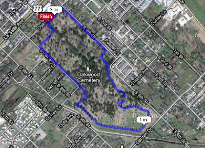
Cemetery
Location: The trail begins at the entrance to Oakwood Cemetery on Oakwood Ave (parallel to and one block away from La Salle), between 4th and 5th street.
Beginning at the Entrance to the cemetery:
Beginning at the Entrance to the cemetery:
- Go through the gate, and go straight
- Take the first right
- Keep following the road and try to pick the roads as close to the fence as possible, to get the longest run, it will eventually curve back around to the front gate.

Length: 2.06 miles
Type: Loop

Dangers to Avoid: This route has always felt safe for me, and the entire place is fenced in. However, I would recommend that you run in the day time.
Things to look for:
- Rocks, dirt and trees. The way it should be
- Maybe some people you knew?
Environment: The trail itself is all asphalt. It's usually a really quiet place. Out of respect, you may have to alter your route if a funeral service is being held.
Sunday, April 17, 2011
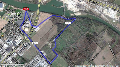
Cameron Park
Location: The trail begins at the entrance to Cameron Park on University Parks Dr.
Beginning at the Parking lot on the edge of the park:


Length: 3.67 miles

Beginning at the Parking lot on the edge of the park:
- Follow the sidewalk West, along the river
- When the sidewalk curves to the left, take the pedestrian bridge on your right
- Follow the sidewalk until it ends and turns into dirt
- Follow the dirt to the Trail Head
- Follow the lower trail (the one about 5 feet from the water) until you reach a clearing where the river splits
- Follow the only road out of that park area until you get to Cameron Park Dr.
- Take a left on Cameron Park Dr.
- Follow Cameron Park Dr. for a little over a mile until you get to the foot bridge you crossed at the beginning of the run
- Follow the sidewalk back to the parking lot


Length: 3.67 miles
Type: Loop
Elevation: The trails are flat, but there are a LOT of hills once you get onto the roads

Dangers to Avoid: The trails are safe, the roads are narrow and winding, and can be dangerous if you don't pay attention. Also, do not run here at night. ^_^
Things to look for:
- Rocks, dirt and trees. The way it should be
Environment: The trail itself is all dirt. The roads are asphalt of course. The trails can be busy at times, but it's a fun place to run. The roads are narrow, and the hills are really steep.
NOTE: Moonlight Drive in Robinson, TX is also a great place to run for hills. It's about a 10-15 minute drive from downtown Waco. It's 5.5 miles long, one way, and it's all hills.
NOTE: Moonlight Drive in Robinson, TX is also a great place to run for hills. It's about a 10-15 minute drive from downtown Waco. It's 5.5 miles long, one way, and it's all hills.
Modified Bear Loop
Location: Although you can hop on to the loop at any point, it officially starts by the Baylor Science Building next to Bagby Ave.
Beginning at the Bagby Ave side of the Baylor Science Building, facing Bagby:
- Turn right and head towards Speight.
- Turn right on Speight and follow it until you hit 7th street.
- Turn right on 7th Street and follow it as it goes through the tunnel of Brooks Flats dorm
- After going through the tunnel turn right on Dutton Ave
- Turn right on University Parks
- Follow the dirt trail until you get to the Stream that enters the Brazos River
- Instead of crossing over the bridge on the sidewalk, go right and follow the sidewalk into campus
- Cross over the first (and only) foot bridge that you come to, between the Fine Arts building and the Baylor Science Building
- Once you cross the bridge take a left and go back out to University parks
- Take a right on University parks and follow the trail until you get to Bagby
- Take a right on Bagby and follow the trail back to the start of the loop

Picture Courtesy of http://www.usatf.org/routes/map/, a great place to plan routes.
Length: 2.5 Miles
Type: Loop
Elevation Changes: This is a flat route. The biggest elevation change is about 10-15 feet.


Dangers: There are several intersection crossings that can be dangerous during the day, (or night).
Things to Look for: Running this route is a great way to familiarize yourself with the campus. The majority of the buildings on campus can be seen from the trail.
Environment: It's a college campus, so there's normally a lot of activity going on. It's not unusual to see a few fellow runners even at midnight.
Brazos River Loop
Location: The trail begins at the entrance to Cameron Park on University Parks Dr.
Beginning at the Parking lot on the edge of the park:


Length: 4 miles
Elevation:
Beginning at the Parking lot on the edge of the park:
- Follow the sidewalk East, towards I-35
- Once you get to the suspension bridge, cross over the river on the bridge
- Take a right once you cross the bridge and follow the sidewalk as it curves under the bridge and heads West
- Follow the sidewalk until you make it to Herring Ave Bridge.
- Cross Over the river on the bridge on the pedestrian walkway on the East side of the bridge
- Once you cross the bridge take the sidewalk on your left as it curves its way down the hill to University Parks Dr.
- Once you make it down the hill, head West until you go under the Herring Ave. bridge that you just ran across
- Get on the sidewalk and follow the right hand branch (don't cross the stream that feeds into the Brazos)
- Follow that sidewalk as it takes you back to the parking lot.


Length: 4 miles
Type: Loop
Elevation:

Dangers to Avoid: This is a very safe route. However, there is one road crossing in Cameron Park. There are a lot of people out in these areas in the daytime.
Things to look for:
- The Waco Suspension Bridge
- Tortilla tossing targets from the bridge
Environment: The trail itself is all concrete, except for the Suspension Bridge which is wooden, and the walkway on the Herring Ave. bridge, which seems to be a plastic composite of some kind.
The Dam Road Loop
Location: The trail begins at the back of the Baylor Ferrell Center and Baylor Ball Park parking lot.
Beginning at the start of the sidewalk at the back of the parking lot:
 Length: 2.5 miles
 Elevation:
Beginning at the start of the sidewalk at the back of the parking lot:
- Run East towards the La Salle Ave parking lot exit.
- Cross over La Salle to the Baylor intramural field's parking lot
- Run across the intramural fields towards the Brazos River
- On the North East corner of the fields take the dirt trail into the trees
- About 50 yards later the trail empties onto a dirt road, follow the road
- The road will split 2 times, go left each time and follow it as it curves
- The road will empty out onto University Parks Drive, just past the Outpost and Big 12 Apartments
- Take a right (West) onto University Parks Drive and head back to the Ferrell Center
- Take the first entrance and head to the back of the parking lot to the head of the sidewalk.

Type: Loop

Dangers to Avoid: There are two road crossings, both of which are crossing La Salle. Possible wildlife once you enter the trees when exiting the intramural fields. On University Parks Dr. you will be running on the shoulder of the road, which is about 4 to 5 feet wide. The dirt road is technically city property I believe...but if you run it according to the directions, there are no signs.
Things to look for:
- The Ferrell Center
- Baylor Intramural Fields
- The concrete dam that keeps the Brazos River deep and slow through downtown
- Trees, and dirt
Environment: About half of the run is on dirt, grass, or gravel, which is nice on the joints. Because it is kind of secluded, I would only run in the daytime.
Page not completed yet
Page not completed yet
Saturday, April 16, 2011
Brazos River Trail
Location: The trail begins at the back of the Baylor Ferrell Center and Baylor Ball Park parking lot.
Beginning at the start of the sidewalk at the back of the parking lot:

Beginning at the start of the sidewalk at the back of the parking lot:
- Follow the sidewalk West, towards I-35
- Once you cross under I-35, go up the steps (10 or 15 steps)
- Take a right at the top of the steps and follow the sidewalk along the riverside
- You will cross under several more bridges until you get to the Waco Suspension Bridge
- The sidewalk will go up towards the road now, along University Parks Drive
- Continue down the sidewalk until you make it to Cameron Park (big sign, can't miss it)
- From here you can explore Cameron Park or head back to your car the way you came


Length: 5.5miles
Type: Out and Back
Elevation:

Dangers to Avoid: This is a very safe route. There are no road crossings. You may have to plow your way through a few ducks or geese, but I have yet to be bitten by one.
Things to look for:
- The backside of the Baylor Ballpark
- The Baylor Women's Soccer Field
- The Baylor Marina
- The football practice fields
- The backside of the Baylor Law School
- The Waco Suspension Bridge
- Cameron Park
Environment: The trail itself is all concrete, but once you pass the suspension bridge you can run in the grass between the sidewalk and University Parks Dr.
Wednesday, April 13, 2011
THE Bear Trail
Location: This popular route is found on the campus of Baylor University. Although you can hop on to the loop at any point, it officially starts by the Baylor Science Building next to Bagby Ave.
Beginning at the Bagby Ave side of the Baylor Science Building, facing Bagby:
- Turn right and head towards Speight.
- Turn right on Speight and follow it through campus.
- Turn right on 8th Street and follow it as it becomes Dutton.
- Turn right on University Parks and follow the sidewalk/trail.
- Turn right on Bagby and stop where you started.

Picture Courtesy of http://www.usatf.org/routes/map/, a great place to plan routes.
Length: 2.25 Miles
Type: Loop
Elevation Changes: It's safe to say that this is a flat route. The biggest elevation change is about 15 feet.
Dangers: There are several intersection crossings that can be dangerous during the day due to college drivers.
Things to Look for: Running this route is a great way to familiarize yourself with the campus. The majority of the buildings on campus can be seen from the trail, including:
Environment: It's a college campus, so there's normally a lot of activity going on. It's not unusual to see a few fellow runners even at midnight.
Subscribe to:
Posts (Atom)